BlueBRIDGE | Gateway
This web page was an access point to a number of VREs deployed and operated in the context of the BlueBRIDGE project. Thanks to the iMarine initiative, some of these VREs are nowadays operated and accessible via the iMarine Gateway, a cloud-based community platform powered by D4Science to help improve fisheries management. Other VREs are openly accessible via the D4Science Gateway.
About BlueBRIDGE and i-Marine
This web page was an access point to a number of Virtual Research Environments deployed and operated in the context of the BlueBRIDGE project, which overall objective was to support capacity building in interdisciplinary research communities actively involved in increasing scientific knowledge about resource overexploitation, degraded environment and ecosystem with the aim of providing a more solid ground for informed advice to competent authorities and to enlarge the spectrum of growth opportunities as addressed by the Blue Growth Societal Challenge.
This BlueBRIDGE gateway has served more than 2.500 users. These users will be supported thanks to the iMarine initiative, which was launched in 2015 to establish and operate an e-infrastructure supporting the principles of the ecosystem approach to fisheries management and conservation of marine living resources, and it ultimately aims at supporting FAO's Blue Growth Initiative.
Read more at FAO - News Article: FAO and Italy’s National Research Council strengthen iMarine ties.


i-Marine supported VREs

Aquaculture Atlas Production System
"to support the generation and the review of aquaculture maps for offshore fish farms and coastal ponds. These maps are generated using satellite Earth Observation imagery."
Global Record of Stocks and Fisheries
"to provide registered users with an environment and tools for accessing stocks and fisheries information collated from three database sources: FIRMS, RAM and FishSource."
Tuna Atlas
"provides services to discover the available datasets at regional and global levels, extract them in several formats and visualise them in an interactive web-viewer of indicators and maps."

Coordinating Working Parties Secretariat
"to support the development and maintenance of the Catalog of the Coordinating Working Parties (CWP) on Fisheries Statistics."
Protected Areas Impact Maps
"to provide scientists with tools to visualise, analyse and report on a range of ecologically important seafloor features within marine protected areas - a key component of Maritime Spatial Planning (MSP)."
Capacity Building for SDG-14.4.1
"to support the FAO Capacity Development Workshops on Stock Status Assessment and Estimation of SDG Indicator 14.4.1 led by Dr. Yimin YE and Dr. Anne-Elise NIEBLAS."
Stock Assessment
"to support the development and validation of data services in support to stock assessment, and accessible for developers and advanced users only."
Vulnerable Marine Ecosystems
"to support the development and storage of FAO Fact Sheets on Vulnerable Marine Ecosystems (VMEs)."
WECAFC Regional Database
"to support the development of the “WECAFC - FIRMS project" during its two successive phases between 2015 and 2019 and the coming third phase."
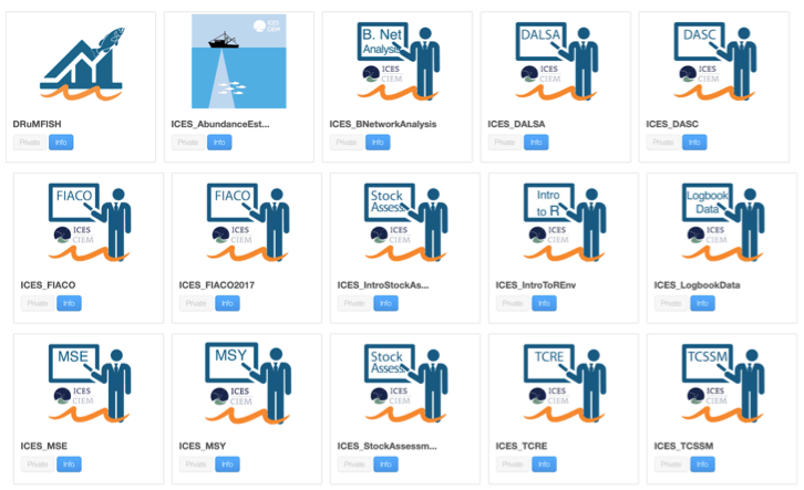
BlueBRIDGE for Scientific training support allowing scientific training courses to be developed and delivered in a cost-effective way. .
These VREs were conceived to support a number of ICES training courses performed by ICES, the International Council for the Exploration of the Sea in Denmark. These VREs were equipped with the following facilities:
- Workspace: for sharing objects of interest;
- Social networking area: for supporting the discussions among members;
- R Studio as-a-Service: a facility enabling users to access a fully-fledged RStudio® working environment directly from the VRE. This environment is integrated with the rest of VRE\VLab facilities, e.g. it is possible to use files from the workspace and to store new files into the workspace.